While the hurricane season appears to have started slowly yielding few events through early August, conditions quickly changed and became favorable for tropical cyclone formation. To date, there have been 8 named tropical cyclones in the Atlantic. We have now crossed the midpoint of the hurricane season, but we are certainly not out of the woods yet as it relates to tropical cyclone activity.
To the left is a comparison of seasonal forecasts released by various organizations and institutions. If these forecasts hold true, we could expect to see 5-6 more named storms over the next 1.5 months. While there is no way to determine how correct the forecasts are yet, current conditions in the Atlantic are largely favorable for tropical cyclone development. This coupled with the number of tropical waves coming off the coast of Africa could lead to a busy conclusion to the 2019 hurricane season.

ACTIVE SYSTEMS
HUMBERTO
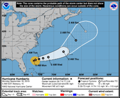
Tropical Storm Humberto formed late Saturday evening in the North Atlantic, becoming the eighth named storm of the Atlantic hurricane season. Prior to last weekend the system had been meandering slowly through an already devastated area of the Bahamas. Luckily sustained winds were minimal, but rain associated with the system was not a welcome sight for the islands. Luckily Florida was spared any significant impact from Humberto, though strong currents and sea swells were observed from east-central Florida up to North Carolina.
As of the NHC’s 11:00 am update, Humberto’s maximum sustained winds are now 85 mph, making it a Category 1 hurricane. The storm is currently moving NE away from the U.S. Only Bermuda remains in the NHC’s cone.

INVEST 97L
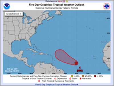
The next system we are keeping a close watch on is an area of low pressure over the central Atlantic that’s producing a moderate-sized area of disorganized thunderstorm activity. Atmospheric forecasts indicate that favorable conditions for tropical cyclone development will persist over the next week as Invest 97L moves northwestward. During this time, a reduction of vertical wind shear is expected which could lead to additional strengthening of the system.
The National Hurricane Center (NHC) has communicated the system has a 60% chance of tropical cyclone formation within the next 48 hours, and 90% chance within the next 5 days. Early hurricane model runs indicate the system could take a sharp turn to the north by Friday as it approaches the eastern Caribbean. This direction change would send the system toward Bermuda or potentially back out to the open sea and away from land. High uncertainty is still associated with this system. Any changes to atmospheric conditions could significantly alter the storms track and intensity.

ON THE HORIZON
Though no additional systems are being investigated currently, weather patterns will continue to evolve over the coming weeks and months which will require us to keep our guard up. Given the hurricane season remains in the “Tropical Red Zone”, a phase where tropical waves are more frequent, it is of paramount importance that we monitor each one closely and effectively asses the likelihood of cyclone formation.