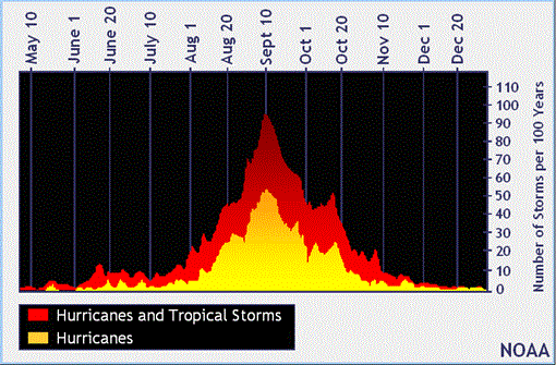
While the hurricane season appears to have started slowly yielding few events since June 1, conditions can quickly change and become favorable for cyclone formation. We have now entered the peak of the hurricane season, or “Tropical Red Zone” as it’s affectionately referred to by many forecasters. Historically, about 2/3 of all Atlantic hurricane activity occurs between August 20 - October 10. To the left is a graph from the National Oceanic and Atmospheric Administration (NOAA) outlining the historical seasonality of tropical cyclones in the Atlantic basin.

NOAA PIVOTS FROM PRE-SEASON HURRICANE FORECAST
Earlier this month (August 8), NOAA issued updates to its pre-season outlook. The update indicated that an above-normal season has a higher chance of occurring (45%) than previously predicted. The dissipation of an El Nino trend in July has allowed neutral conditions to propagate throughout the basin, which could lead to more conducive conditions for tropical cyclone formation.
ACTIVE SYSTEMS
Chantal
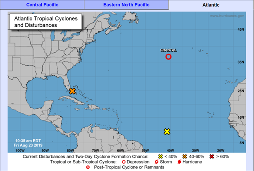
Tropical Storm Chantal formed Monday evening over the warm waters of the Gulf Stream in the North Atlantic, becoming only the third named storm of the Atlantic hurricane season. However, by Wednesday night Chantal had been downgraded to a tropical depression. Remnants of Chantal pose no threat to land but will create rough seas for any ships (or fish) moving through that area. Strong vertical wind shear continues to impact Chantal. This wind shear and dry stable air present will prevent Chantal from strengthening again.

INVEST 98L
The next system we are keeping a close watch on is an area of low pressure over the northwestern Bahamas (orange X above) that’s producing a moderate-sized area of disorganized thunderstorm activity. Invest 98L is forecast to move near or over Florida tonight (Friday) which will slow development during the next day or so. Forecasters indicate that favorable conditions for development are present once Invest 98L moves northeastward back over the Atlantic Ocean on Saturday/Sunday. The National Hurricane Center (NHC) has communicated the system has a 40% chance of tropical cyclone formation within the next 48 hours, and 70% chance within the next 5 days.
INVEST 99L
The NHC predicts a 20% chance that Invest 99L (yellow X above) will become a tropical cyclone in the Caribbean during the next five days. Invest 99L formed from a tropical wave located about 1400 miles east-southeast of the Windward Islands, and currently contains a disorganized area of showers and thunderstorms. Various models show general agreement that Invest 99L will maintain a west-northwesterly track toward the Windward Islands. However, the computer models diverge greatly regarding the track once Invest 99L reaches the Caribbean.
ON THE HORIZON
According to the NHC, 60 tropical waves track across the Atlantic Ocean each year. Roughly one in five of these tropical waves becomes a tropical cyclone. Tropical waves are the origin of approximately 60% of tropical cyclones in the Atlantic and approximately 85% of major hurricanes (Category 3 and above). Given the hurricane season has entered the “Tropical Red Zone”, a phase where tropical waves are more frequent, it is of paramount importance that we closely monitor each one closely and effectively asses the likelihood of cyclone formation for the benefit of our policyholders.