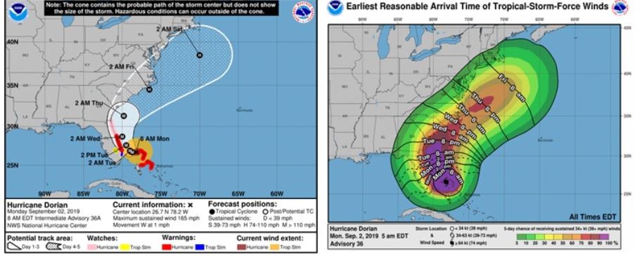

As of 8:00 am EST on Sept. 2, Dorian is 120 miles east of West Palm Beach Florida, moving W at 1 mph. Current maximum sustained wind speeds are 165 mph, making it a strong category 5 hurricane. Over the last few advisories, the NHC continues to forecast a northward turn for Dorian. However, in preparation for the northward turn, Dorian’s forward speed has skidded to a halt. Over the next 18 hours Dorian is expected to move very little. Dorian is expected to reach its closest proximity to Florida near Brevard county sometime Tuesday night or Wednesday morning. Residents on the eastern coast of Florida should be aware they may experience increased winds for a longer duration of time than originally forecast due to the Dorian’s slowing feature. It is also important to remember that even moderate wind speeds can damage a building if exposed to them for a prolonged period of time.
While the current advisory suggests that Dorian will likely skirt Florida, it is paramount to remember Florida remains in the cone of uncertainty and conditions could still change. Even this close to landfall, uncertainty is still high.
The operational models continue to show more agreement regarding Dorian’s likely track, though with each subsequent update the tracks are drifting a little west back towards Florida. This is due to a change in the upper level atmospheric steering currents. As these currents to continue to change, they will affect how soon Dorian begins to turn northward. As a result, the NHC has shifted the average track west slightly in the past few advisories. If Dorian’s track continues to shift westward, this will create a very different scenario regarding the impact to Florida. The next 24-36 hours will be critical in determining the storm’s potential impact as it turns and begins to accelerate again.