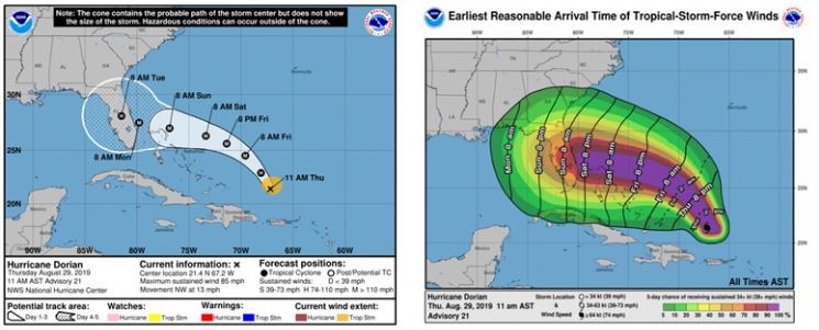

As of 11:00 am EST on August 30, Hurricane Dorian is 255 miles ENE of the southeastern Bahamas, moving NW at 12 mph. Current maximum wind speeds are 110 mph, putting it on the cusp of becoming this season’s first major hurricane. The NHC currently expects Dorian to make landfall as a Category 4 hurricane with windspeeds of 138 mph. Given Dorian’s projected intensity and forward velocity at landfall, a powerful storm surge is very likely for areas in and around West Palm Beach and to the north. No reliable estimates of storm surge height are out yet, but yesterday the USGS installed more than 280 instruments along the eastern coast of Florida, Georgia, and South Carolina that will capture various storm tide information as Dorian comes ashore.
A slow west-northwestward to westward motion is forecast to begin tonight and continue through the weekend. This will lead to Dorian’s forward velocity slowing a bit further. On this track, Dorian should move over the Atlantic well east of the southeastern and central Bahamas today, and approach the northwestern Bahamas sometime Saturday.
The operational models are beginning to show more agreement regarding the likely track the storm will take. Since last night, the Euro model and the HWRF models, two of the most historically reliable operational models, forecast Dorian to make landfall around Palm Beach County, and then turn northward and move quickly through the state of Florida. More convergence is likely over the next several days as atmospheric conditions continue to firm up.