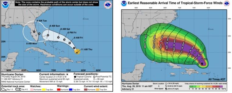

As of August 29 at 11:00 am EST, Hurricane Dorian is 150 miles north of Puerto Rico, moving NW at 13 mph. Current maximum wind speeds are 85mph, but Dorian will spend the next three days over the Atlantic and will have little wind shear to compete with as it intensifies. The NHC currently expects 130 mph, Category 4 wind speeds, upon landfall with the HWRF model agreeing.
The operational models show Dorian continuing NNW for a few days before it turns WNW towards Florida. Since last night, there has been some improvement regarding Dorian’s landfall location. The Euro model is forecasting a landfall in West Palm Beach, and the GFS model forecasts a landfall south of Titusville. More convergence is expected over the next several days.
After landfall, Dorian is expected to make a northward turn. The models are currently diverging regarding the timing of the turn after landfall, which is why the NHC’s cone balloons after landfall. This timing leaves open the potential for Dorian to exit into the Gulf, further intensify, and make a second landfall in the panhandle.